Eminently suitable for any GM who needs a world - be it the next planetfall for a starship crew or the setting for a fantasy game - this is a large map provided both as a JPEG and as an Adobe Photoshop file, ready for you to annotate as appropriate.
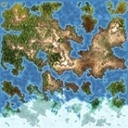
It shows one massive sprawling continent and a number of islands of various sizes, some forming the fringes of what appears to be a landmass on the southern pole of the world, much of which is covered by ice. Most of the main landmass appears temperate, with a mix of woodland and plains and a central rambling 'spine' of mountains. Some areas can be designated as marshy or desert - there are a range of textures, and it's up to you to decide precisely what they represent. Lots of scope for you to let your imagination run wild.
When examined closely, there are a lot of coloured dots on the temperate areas (and on the mountains) which can be given names and use to denote settlements, scattered around in a quite natural looking way... although I'd have expected more to be in coastal areas and round lakes to serve as ports and fishing villages. A notable absence is that there are no rivers. As well as 'settlement markers' the mountain areas have mysterious little lines, these could possible serve as routes over or through the peaks.
Resolution is pretty good, it is not until you enlarge it to 3 or 4 times that it begins to be noticeably pixellated, which means that once you have determined the overall arrangement of the 'world' you can make a start on more detailed maps of particular areas of interest - depending on the scale that you decide upon, of course. Is this the whole world, or just a part of it? Scope for you to decide, depending on your needs.
Personally, I prefer to start without the settlement markers - easy to arrange using the layers in the Photoshop files! - and determine the locations of habitation based on the geography rather than the rather arbitrary placement of the ones provided. I'd also like to know if it's purely for personal use or if a world created on this map may be used in a published work. Overall, though, it's a delightful map fit to be home to a lot of adventures!
Return to Atlas #3 page.
Reviewed: 2 November 2012
